

Mound Bottom is located in Kingston Springs approximately one mile from US Route 70. It is part of Harpeth River State Park, managed by the Department of Environment and Conservation, and visits are prohibited without the permission and accompaniment of park rangers or the Tennessee Division of Archaeology. To visit, contact Harpeth River State Park, keep abreast of upcoming hikes on the events calendar or Facebook page, or contact TDA. The Pack Site is NOT open to the public and is on private property.

Tucked away in a meandering bend of the Harpeth River, with cliff walls overlooking the site, you might not even realize that an ancient Native American mound center hides in plain sight. If you are canoeing or kayaking down the river, you may paddle right past it, never noticing it. No signs point to it; there are no directions to guide you. It is intentionally concealed yet not completely forbidden. It’s fairly well studied, yet there are mysteries to be revealed. And as far as prehistoric sites in Tennessee go, this is one of the most significant. I’m speaking of Mound Bottom State Archaeological Area, just outside Kingston Springs in Cheatham County, and it is hands down one of my favorite mound sites in the state. But why is it purposefully hidden from the public, and why should you try to visit? Read on, and let’s explore.

First, let’s start with a little pre-history. Mound Bottom was most likely founded in the early eleventh century CE by Native Americans who came here from what is called the American Bottom: sites with rich soil and rivers in modern day Missouri and Illinois. This area almost certainly had ties to Cohokia, one of the most important Mississippian sites in the entire United States, located just outside of St. Louis, MO.
These individuals arrived in modern day Tennessee travelling along the Cumberland and other rivers until reaching the Kingston Springs area, possibly in an effort to expand their regional trading networks. In fact, Mound Bottom is just one of thirty-seven known sites on the Harpeth River, S. Harpeth River and Turnbull Creek area, a 5km radius. These sites include small mounds, stone box graves, family farms, and at least two rock art sites! The most significant of these adjacent sites is called the Pack Site, and it is only a mile upstream from Mound Bottom on private land. Mound Bottom has one large ceremonial mound and thirteen known smaller ones, while the Pack site has one large mound and twenty smaller ones. Together, “the Great Mound Group” make up the largest Mississippian mound grouping in Tennessee, and one of the largest in the American Southeast!


Between 1100-1200 A.D., Mound Bottom was flourishing and spreading, replacing or incorporating small chiefdoms, first along the Harpeth River, then eastward through the Nashville Basin. Along the way, the traditions from the American Bottom merged with those of the local population, creating new cultural customs which became known as the Middle Cumberland Mississippian Culture. These late prehistoric people also had rich ties to the Great Lakes, Gulf Coast and the Appalachian Mountains! By 1350 A.D., however, Mound Bottom and the Pack site were no longer used as major centers and were instead burial sites, as people moved away from the idea of chiefdoms and created independent villages such as the one in Sellars Farm.
Since there is no visitor’s center you will have to do a little work to be able to visit Mound Bottom. There are three ways to do this: First, you can keep up with ranger led hikes through the Upcoming Events page and sign up. You can also contact the rangers at Harpeth River State Park and arrange for a group to come visit, or you can contact the Tennessee Division of Archaeology to see if they will have any visits you can be part of. I have personally visited Mound Bottom on sunrise hikes with a park ranger, have been on private group hikes, and been on a hike arranged through the Middle Cumberland Archaeological Society, all of which were fun and informative. Once your trip is arranged, you will receive details that will most likely have you park in a lot facing the Harpeth River along Hwy 70. From there, a ranger will guide you along back roads to a protected area, about a mile away where you will park your car. A locked gate will be opened, and you will begin your hike. Wearing sturdy hiking shoes is recommended, as the road that leads down to the mounds is washed out and there is no easy trail to traverse.


As you walk along the road, you’ll pass through a dense wooded area first. My first visit to Mound Bottom was with a Native American group, and this path was strewn with turkey feathers, a magical sign! You will notice along the right-hand side there is a steep bluff looking down at the Harpeth River. Then suddenly, on your left, you’ll see the sign for the Mound Bottom State Archaeological Area, and behind it you’ll glimpse the largest mound in the area, Mound A. The view is fantastic, and now you understand why this 7-acre area is so protected. It is serene, peaceful, and mysterious. Walking towards the large mound, you notice more mounds, a dozen or so, that are smaller, all around. An area with trees on the right was once the site of a house and burial sites have been found there. Climbing to the top of Mound A, you survey your surroundings and can’t help but feel the energy of the area move through you. The hairpin curve of the river surrounds you on three sides, and as you gaze upon the cliffs you feel yourself becoming still and quiet. I love sitting on this mound and ideally would do so for at least an hour with only the birds to disturb my thoughts. There is something about this place that is tranquil and at the same time leaves a slight tingle on the skin. As you sit on the large mound and look out on the plaza and small surrounding mounds, you are enveloped here by spirits in a way I've never felt in other mound sites. No wonder the first travelers saw this place and decided to stay here!


Before and since the first archaeologists came on the scene in the late 19th century, this area was heavily farmed, which took a toll on the size and shapes of the mounds. Today, Mound A measures approximately 246 feet along each side and stands around 36 feet tall (in an 1878 map the height is identified as 45 feet). The rest of the thirteen mounds surrounding the plaza today measure between two and thirteen feet tall. Mound A was enlarged in four or five stages, and at one time had a staircase centrally located on its eastern side. In the late 19th or early 20th century, however, a ramp was cut into the north face, and the mound became one of the most scenic watermelon patches around! But standing on its summit today, you can easily envision one or two structures serving as a temple or housing for a chief or priest. As you walk around the site, imagine that some of the surrounding plaza would not be grassy but instead hard packed earth, and that the tops of the mounds were covered in clay or colored earth. Houses, built of wattle and daub, would dot the site, and family cemeteries would also be present.

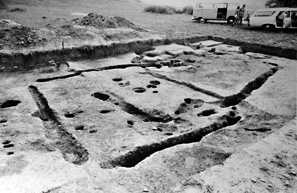


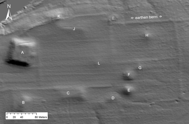
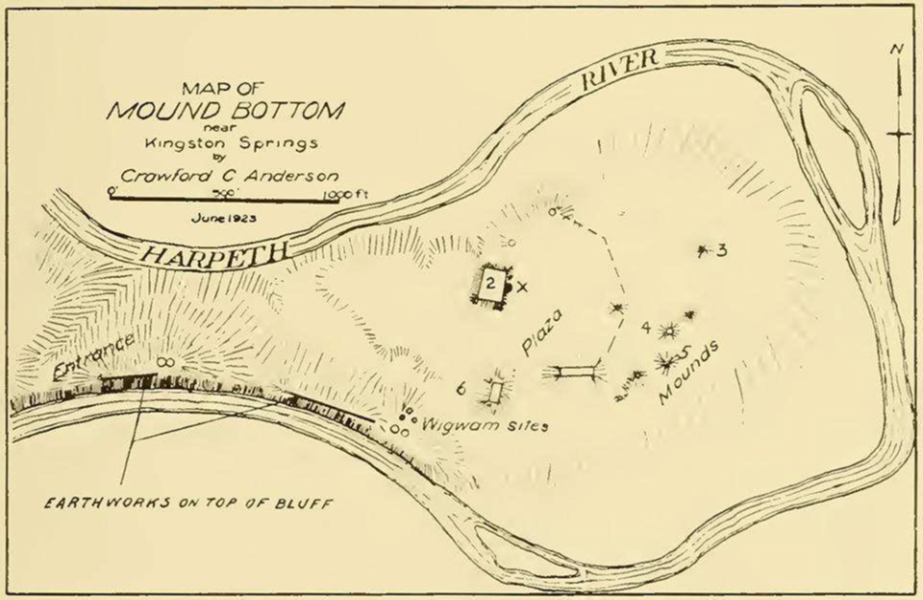
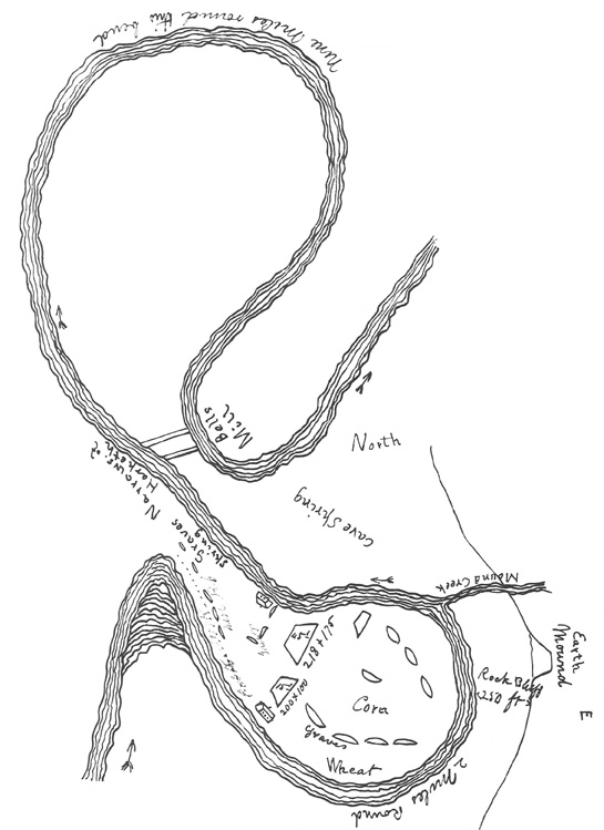
Mound Bottom and the Pack site were both said to be protected by palisades. These were first noted by Judge John Haywood in 1823, who also wrote of eighteen mounds with an earthen wall, two gateways, and a well-worn path to the Pack Site. (The walls were also noted in 1876 by Joseph Jones who said the fortifications enclosed a number of mounds, although others believe these could just be trenches to define the mounds and build them, or embankments made by plowing practices.) Today the path noted by Haywood to the Pack site is mostly overgrown with trees and hard to see, but the connection with the two sites is clear and very interesting to contemplate! Earthworks have also been described by the first archaeologists on the scene along the neck of the river, and these may have been defensive in nature. The first of two maps below were created by Crawford Anderson in 1923, and the second by Edwin Curtiss, who conducted who excavated Bottom for the Peabody Museum at Harvard in 1878. The last photo is a recently conducted LiDAR model showing mounds and earthern berms form the Tennessee Division of Archaeology.
“All around the bend, except at the place of entrance, is a wall on the margin of the river. […] On the north side of the bend and wall, is a gateway, and also on the south. On parts of this wall, at the distance of about 40 yards apart, are projected banks, like redoubts on which persons might have stood.” – Judge John Haywood


Directly across from Mound Bottom on one of the bluffs facing the plaza is May’s Mace Bluff. It has a great view of Mound Bottom and is a fascinating side trip to take while you’re here. There are a number of beautiful and mysterious examples of petroglyphs or rock art found on cliffs along the Harpeth River in this area, and Mace Bluff is one of only ten or so known petroglyphs in the Southeast that feature a ceremonial mace. It’s obvious there is some spiritual significance of the mace to Mound Bottom, and it’s a mystery yet to be solved!


Starting in 1939, there were a number of attempts to make Mound Bottom a state park and Native American educational center. Finally, in 1971, the site was placed on the National Register of Historic Places, and in 1973 the site was purchased by the Tennessee Department of Environment & Conservation. It became part of Harpeth River State Park in 2005, and there are still hopes that one day a visitors’ center will make this incredible prehistoric site open to the public year-round. It may not be the easiest archaeological park to visit, but a trip to Mound Bottom is more than worth your time and effort!
To visit May's Mace Bluff, go west on I-40 to the Montgomery Bell exit. Go north on Hwy 70 to Cedar Hill Road, then drive 1.5 miles to Scott Cemetery and the Mound Bottom historic marker. A short walk south of the cemetery is the foot of Mace Bluff, and a trail head begins here. The hike is moderately difficult. Rock Art Sites
REFERENCES:
WPA Excavations at the Mound Bottom and Pack Sites in Middle Tennessee, 1936–1940. Michael C. Moore, David H. Dye, and Kevin E. Smith
Comments